Poverty, New Grocery Zoning, Community Gardens in NYC (click here for map link).
Introduction
Food insecurity—lacking sufficient access to affordable, nutritious food—is a growing, though not new, issue in the United States. There are many contributing factors to this ongoing tragedy ranging from socio-economics, to politics, to geography. This has been a persistent problem but the COVID-19 pandemic of 2020-2021 has worsened the situation. A 2021 report notes that between 26 and 29 million Americans (approximately 9% of the total population) have reported not having enough food during the pandemic. That same report states that in New York 11% of people surveyed, including 14% of households with children, experienced food shortages. In fact, a recent estimate indicates that one-in-four children (25%) in New York currently may be experiencing food insecurity. The Food Research and Action Center (FRAC), which advocates for the eradication of poverty level hunger, notes that older adults have also been hard hit by food shortage and hunger in the wake of COVID-19. In addition, a study carried out by researchers at Northwestern University indicates that food insecurity is acute among those making less than $25,000 per year but extends to include those making $50,000 per year as well (i.e. it also affects the “middle class”). Further, their research has shown that food shortages are especially prominent in Black and Latin-X households. In other words, hunger is a very real issue in the United States and is experienced across a wide demographic spectrum.
Food and Housing Costs
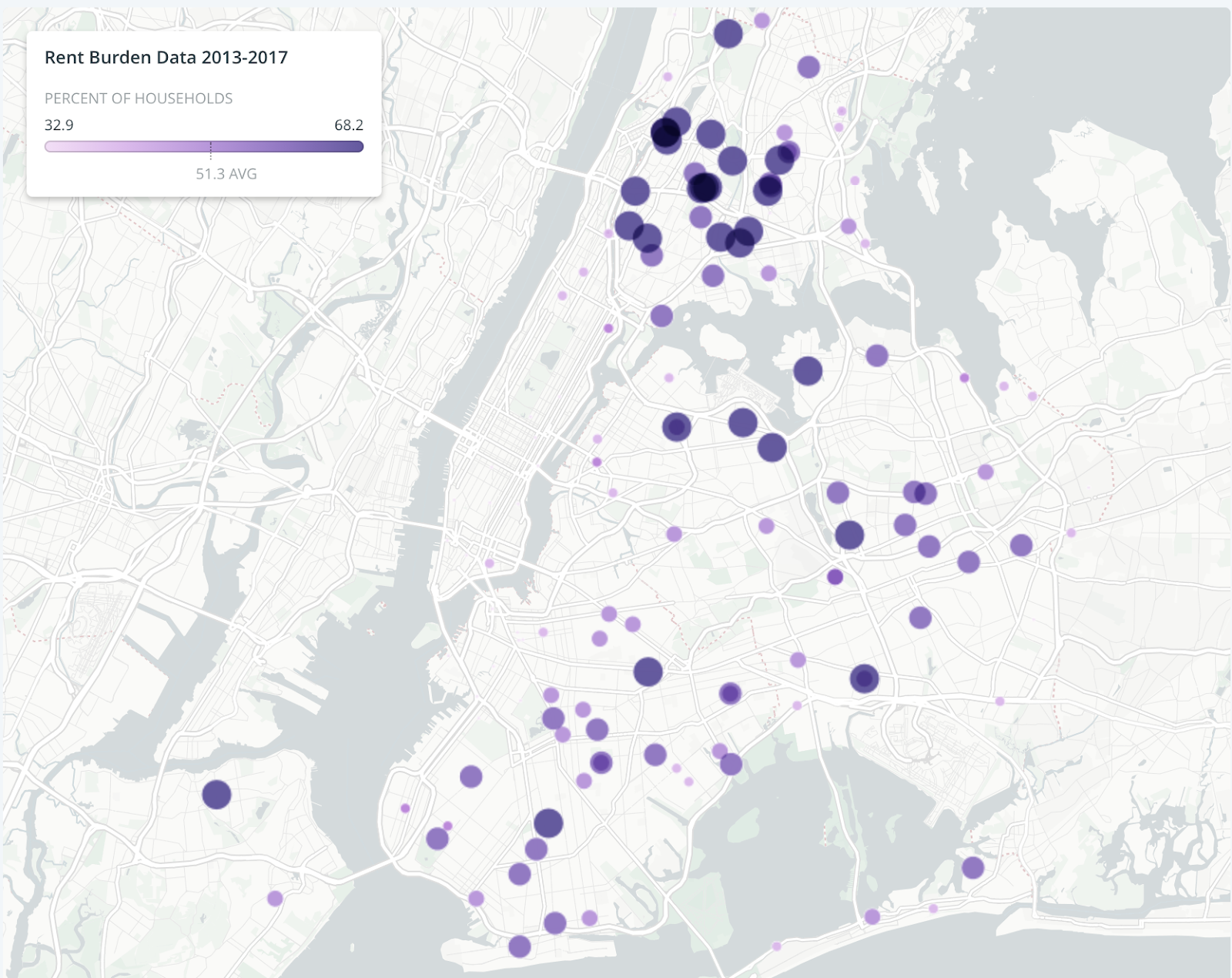
Map of New York showing neighborhoods with rent-burdened households
In many cases, the issue of food shortage appears to be strongly dependent on employment and socio-economic status. Food costs have risen and have added to the burdens carried by those already struggling to meet high costs of living. The situation is certainly troubling among members of the middle class who recently have experienced unexpected economic hardship during the pandemic thanks to record unemployment levels. It has, however, been a persistent problem for those whose economic status has been and remains historically less secure. A 2020 report by the United States Department of Agriculture (USDA), for example, notes that food insecurity is particularly high among people participating in Housing and Urban Development (HUD) assistance programs. According to HUD, these programs are open only to low-income individuals and families. People living in HUD housing, however, are not the only ones struggling with the cost of putting a roof over their heads. The impact of rising housing costs has had an effect on an ever-growing section of the population. A housing study reported on the New York City Housing website notes that median gross rent exceeded median renter income in 2009 and has accelerated ever since. A 2019 study reported by the National Low Income Housing Coalition found that being rent-burdened—or having the cost of housing exceed 50% of income—is associated with greater food insecurity, child poverty, and poor health outcomes. The number of households who fall into this category can, and does, increase in cities with a high cost of living like New York. According to a 2020 construction research group report, 44.7% of households in New York city are rent burdened.

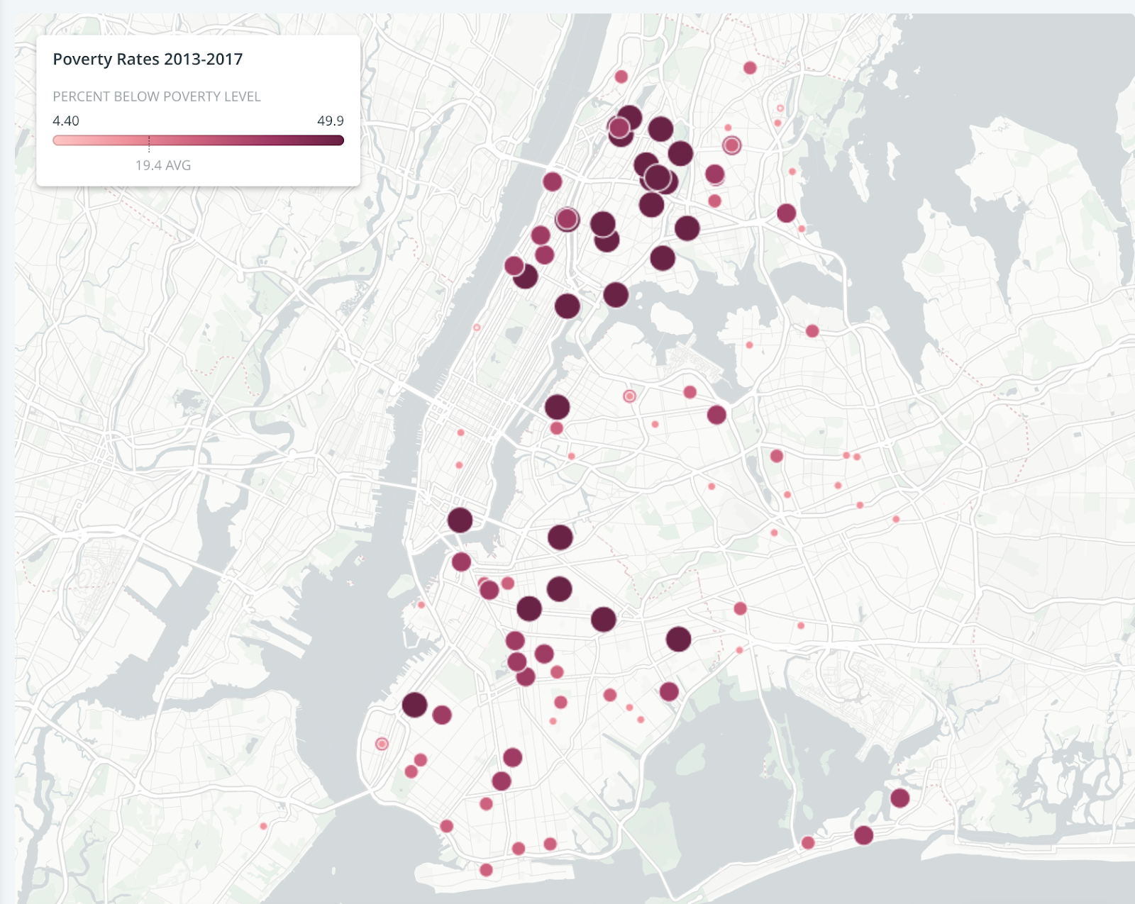
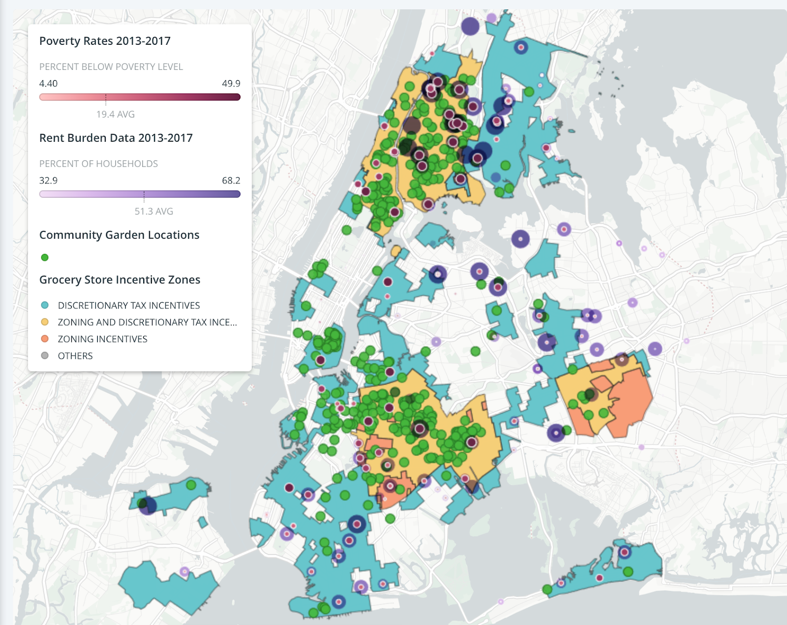
Rent-burdened households and areas with people living below the poverty level
This is particularly important as many of the same neighborhoods in which households are rent-burdened are also home to people living in poverty. As a result, these are areas in which there is strong likelihood that residents are experiencing food insecurity.
Attempts at Relief
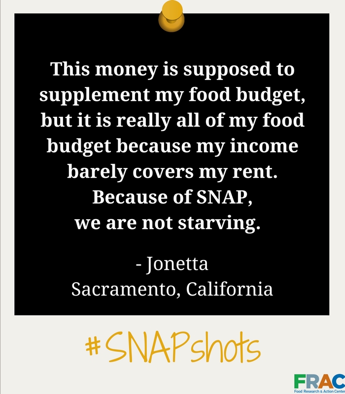
Some efforts have been made to help provide relief for people struggling to meet food costs as well as rent. The hotly contested social benefit known as the Supplemental Nutrition Assistance Program (SNAP), for example, is the only way that many recipients can afford food because their income is absorbed by rent costs. One of the featured “SNAPshots” on the FRAC website quotes a recipient in California as saying “… my income barely covers my rent. Because of SNAP, we are not starving.” A SNAP recipient is able to use an Electronic Benefits Transfer (EBT) card to pay for groceries, though with restrictions on what may or may not be purchased. The increase in food insecurity during the pandemic has led to a modification of this system with the introduction of the Pandemic EBT, which according to FRAC helps offset the food burdens on families who lost access to free meals when schools closed because of COVID-19. The aid provided by these and other programs, however, is not secure even when there is evidence that it is working. A good example of this is the extension of unemployment benefits made available by the CARES act. An investigation published in the Journal of the American Medical Association (JAMA) showed a strong correlation between the receipt of extra benefits and a reduction in food insecurity. Despite its positive impacts on personal well-being and the economy, the extension of these benefits was the victim of partisan politics in the run up to the 2020 election when it became a target of Republican objections to any sort of social welfare program.
Food Swamps and Deserts
Even when aid is available, a further issue complicates access to food—geography. In dense urban spaces like New York, it is not uncommon to encounter “food deserts” or “food swamps.”
A food desert is an area where access to affordable and healthy food is limited or non-existent because grocery stores are absent or are too far away. As a result, residents are forced to find less healthy food options, which can (and do) have negative impacts on health. In neighborhoods like Bedford-Stuyvesant, for example, New York City data shows that the ratio of unhealthy options like Bodegas to Grocery stores is an astonishing 57:1.
A food swamp is a region that may have access to some healthy foods but is overwhelmingly dominated by less healthy options (i.e. fast food chains). In response to the profusion of junk food on offer, some cities like New York have proposed so-called sugar taxes to make less healthy food financially unattractive. Given that such foods are often the less-expensive option, however, raising taxes on them ends up making food affordability worse for poor residents.
Cities have also worked to find ways to bring grocery stores to food deserts and, by extension, the underserved communities located in them. An example of this is the FRESH (Food Retail Expansion to Support Health) initiative in New York.
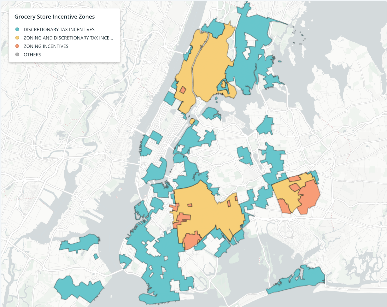
FRESH Zoning NYC
The program provides tax and zoning incentives to attract grocery store operators to open businesses in particular neighborhoods and areas. These incentives include: 25-year land tax abatements, stabilized building taxes for 25 years, exemptions from sales tax on materials used for construction or renovation of sites, deferred mortgage taxes, additional development rights, and waivers of city wide parking space requirements.
The Question Under Consideration
Programs like FRESH are certainly well-intentioned but are they necessarily the best, or only, approach to finding ways of connecting people struggling with food insecurity with what they need? After all, one of the underlying issues at stake with food insecurity is that those suffering from it often do so because they can’t afford the cost of both food and rent. How does opening a grocery store chain, which will charge ever-increasing market rates for its goods in order to stay in business, address this problem? Certainly actions like mandating a living wage, greater regulation on capping rents as a percentage of income, and instituting a guaranteed minimum income would go a long way in helping to solve some of the underlying inequalities that contribute to food insecurity. These will not, however, address the matter of access to food in areas without grocery stores. Neither will offering corporations millions in tax exemptions, waivers, and give-aways, which arguably will not positively impact the communities they are meant to serve.
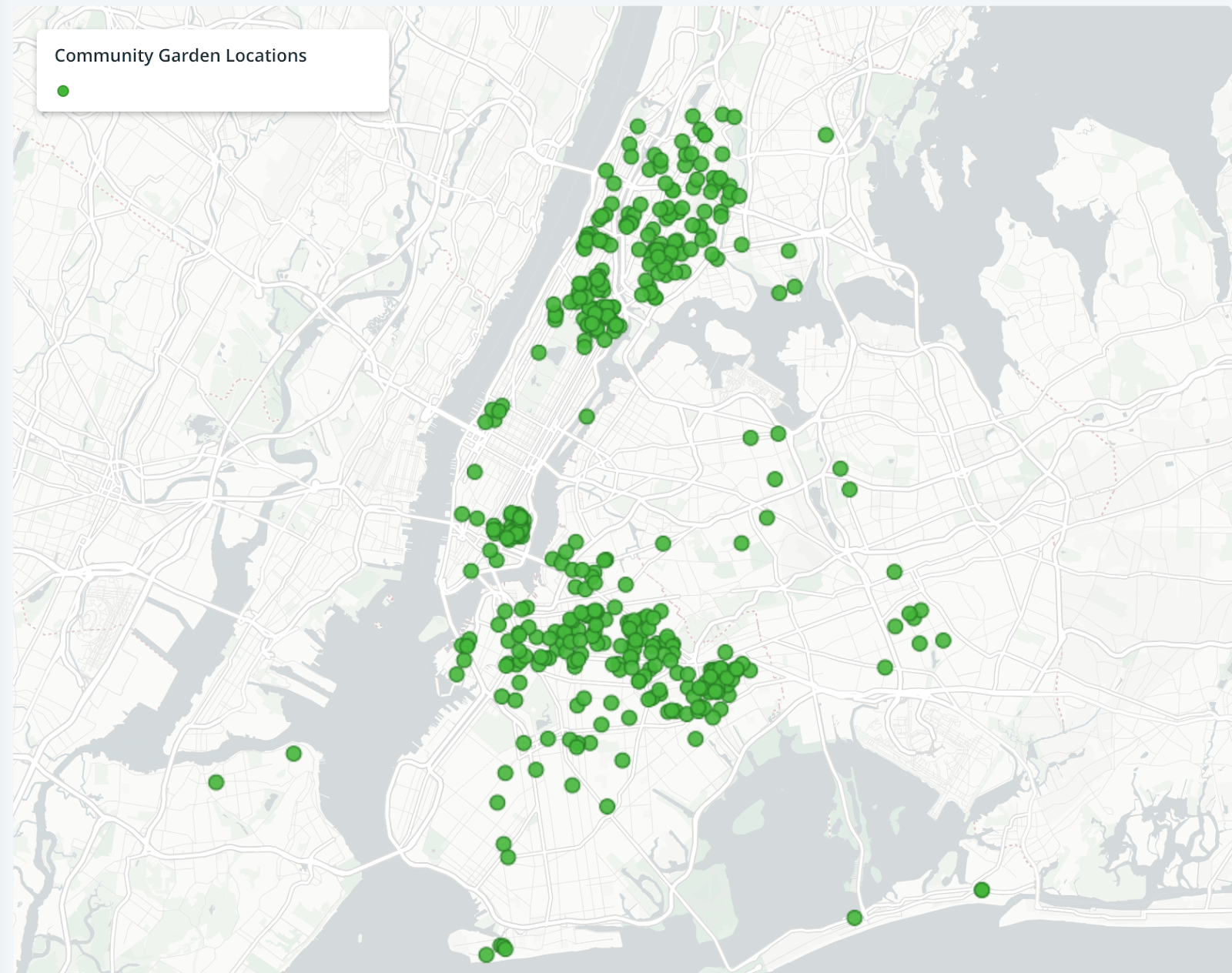
Community Garden Locations, NYC
The question arises of where might city and state funds go that could have a more immediate impact? To my mind, the money earmarked for tax breaks, the zoning waivers directed toward yet another set of retail spaces, and the quarter-century protections offered to corporate entities could find better use when provided to cooperative community garden spaces dedicated to feeding the communities in which they are situated. To explore this further, I created a map of the city that shows the locations of community gardens, households burdened by rent, neighborhoods in which people are living below the poverty level, and the city’s proposed FRESH zones to show how a more immediate, and sustainable, option may already be within reach.
Inspiration
My primary inspiration for this project was a segment in a BBC series titled Monty Don’s American Gardens (BBC, 2020).
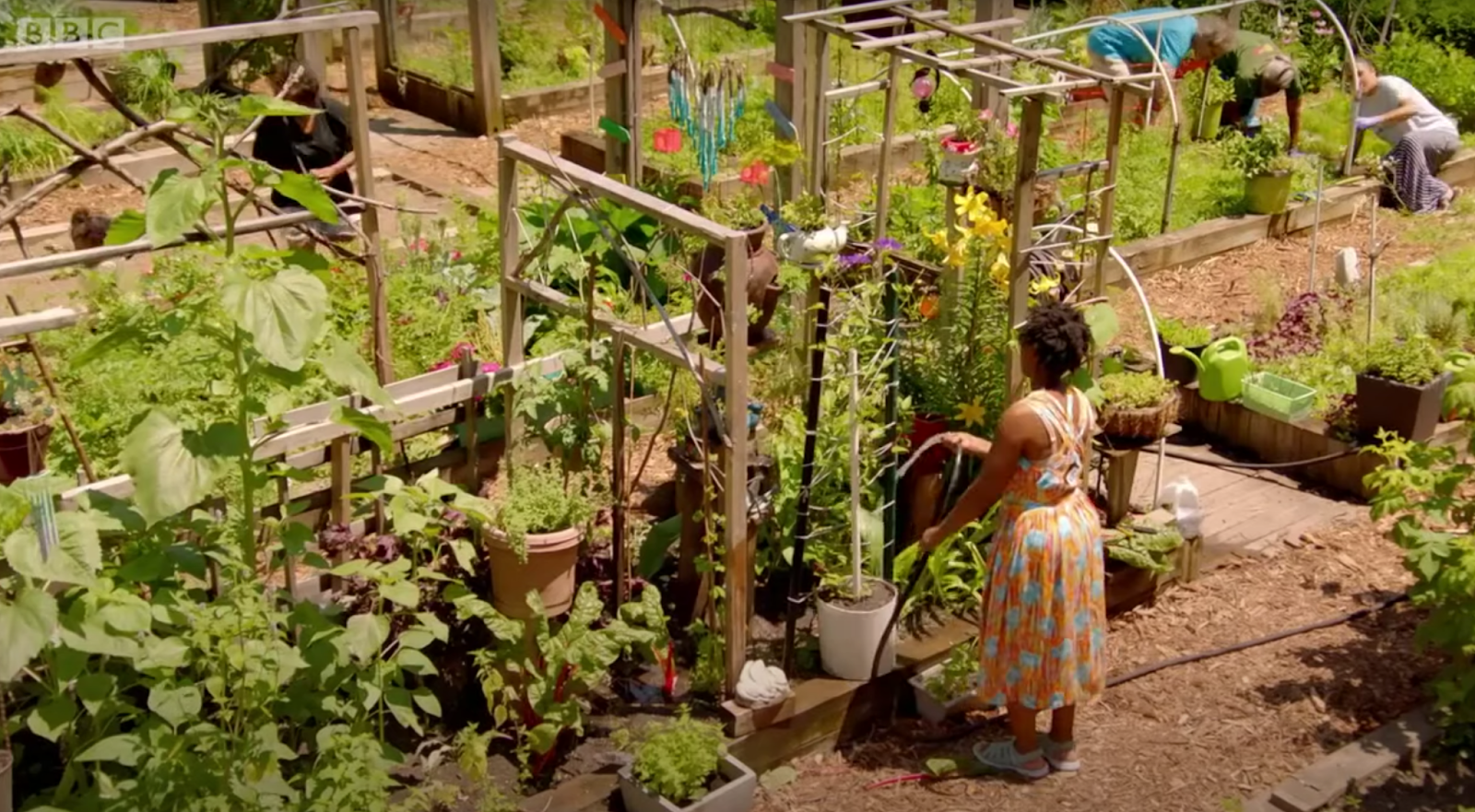
Target Bronx Community Garden, Monty Don’s American Gardens, Episode 1 (BBC, 2020)
In the first episode of a three-part series, the host visits the Target Bronx Community Garden in the Bronx, NY. The gardeners who use the space grow a variety of vegetables, fruits, and herbs to meet their needs as well as those of community members. The garden is just one of many across the city located in areas affected by poverty. Here, land is being used by local people rather than commercial entities to help feed the surrounding community. A second point of inspiration came from the work of City Harvest, which began in New York in 1982 as a cooperative with the mission of getting food to struggling families. The organization rescues food from restaurants, grocery stores, and other venues that would otherwise go to waste and delivers it to soup kitchens, food pantries, and other organizations who serve those in need. These approaches—community gardens and non-profit food distribution networks—seem to provide a viable way of addressing the issue of hunger and food insecurity in New York.
Materials and Data
The map for this project was created using Carto, which is a tool for performing various types of spatial analysis. The data at the heart of the map came from various New York City data portals and included datasets for FRESH zoning, poverty levels, rent-burdened households, and community garden locations. Each of these datasets is public and is provided on New York City websites for use and analysis.
Method
A basemap was created in Carto by using the FRESH zoning data, which contained location data and shape files necessary to accurately place them. Next, datasets regarding poverty levels and rent-burdened households were processed before being imported to Carto. The datasets were formatted with notes and other extraneous information that would impede Carto’s ability to read and understand the data. I made a copy of the original datasets, removed this information in OpenRefine, and imported the cleaned data into Carto as .csv files. Unlike the FRESH zoning data, the datasets on poverty levels and rent-burdened households did not contain latitude, longitude, or shape file information. As a result, I used Carto to geocode locations based on borough and neighborhood. I then imported the garden location data into Carto as a .csv file. This data contained latitude and longitude for the gardens so geocoding was unnecessary.
The shape files for the FRESH zoning information marked out the areas of the city covered by this program. For the poverty, rent-burden, and garden information, I chose to use point data to situate them in relation to the large administrative areas covered by the zoning plan. The strong link between neighborhoods with people living below the poverty level and those with rent-burdened households meant that the point data for each often overlapped. To adjust for this, I increased the size of the rent-burdened household points so that the poverty level points would remain visible at their center. I also added pop-up data (on click) to provide further information about both poverty and rent-burdening for each type of point. Similar pop-up data was used to identify the garden locations throughout the city.
Results
The map shows that the FRESH zoning areas coincide with many areas in which poverty and rent-burdening occur in the city. There are notable exceptions such as North Corona and East Elmhurst, which are not covered by the zoning project but are areas of both rent-burdening and poverty. The map also shows a profusion of community gardens all throughout the various zones and intermingled among areas with high poverty and rent-burden rates. Certainly, not all of these gardens are dedicated to food production but, instead, grow flowers or act as small park-like spots for members only. The sheer number of gardens, however, provides an indication that creating and sustaining plots of land in the city that produce food for the larger community is possible. Spaces like the Target Bronx Community Garden demonstrate that it is not only possible, but is in fact happening. This raises some important questions. First, how might city incentives make more food-bearing garden plots possible so that the amount of fruits and vegetables available can increase? Second, how might non-profit food distribution networks like City Harvest help make an increase in produce available to those in need? The answers to these questions are outside what this map can show and require careful analysis and coalition building among policy makers and community members.
Future Directions
The map in its current state shows some of the factors that need to be considered when thinking through ways to help alleviate food insecurity in New York. It would be interesting to continue to enrich this information with data on the location of food pantries and soup kitchens, data on how many people per neighborhood are served by such locations, the distribution networks used by organizations like City Harvest (i.e. which locations do they link together for food rescue, storage, and delivery), and what policy barriers might exist in the city and state to using community garden space vehicles for helping those in need. Clearly, this is too much to load onto a single map. It would be helpful to develop a dashboard of information as well as a means of seeing individual map layers that can be investigated and overlapped by those interested in these issues.